
 Home
Home


Peak Easy
Visually identify the hills that are nearby, in Great Britain

1,000+
Total Global Downloads-
Bundle ID
com.colton.peak_easy
-
Developer
Douglal -
Category
Books & Reference -
Price
Free -
Update Time
Jan 1, 1970 -
0 Ratings
0
-
Bundle ID
com.colton.peak_easy -
Developer
Douglal -
category
Books & Reference
-
Price
Free -
Update Time
Jan 1, 1970 -
0 Ratings
0
 Screenshots & Media
 App Info
 ***********
 Description
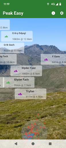
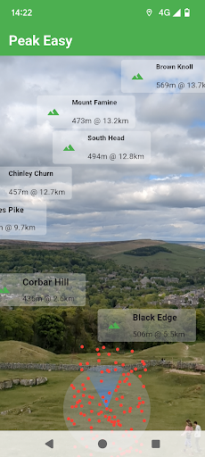
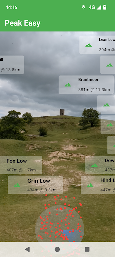
Real time hill radar. Using your phone's camera, you can see the name, height and distance of hills that you can see around you and that are within 10-50 km of your location.About 6,000 hills in Great Britain are covered, including:
Most English and Welsh TuMPs (30m prominent), Wainwrights and Ethels.
Scottish HuMPs (100m prominent).

 Popular IAP
--
 Version History
| Version | Time |
| Jan 1, 1970 | Jan 1, 1970 |
| 2.1.0 | Sep 22, 2025 |
| 2.0.6 | Aug 19, 2025 |
| 2.0.3 | Aug 12, 2025 |
| 1.4.0 | May 30, 2025 |
| 1.3.3 | May 21, 2025 |
| 1.2.0 | May 20, 2025 |
| 1.1.4 | May 8, 2025 |
Preparing
Ranking Trend
Last 7 Days
Last 30 Days
 Customize
Last 7 Days
Last 30 Days
Customize
Last 7 Days
Last 30 Days
Customize
Last 7 Days
Last 30 Days
Customize
Download Trend
Last 7 Days
Last 30 Days
Last 90 Days
Customize
More by【Douglal】
| # | App | App Category | App Price | App Initial Release Date | |
| 1 |
|
Walk Derbyshire
Douglal
|
Health & Fitness | Free | 15 Apr 2024 |
| 2 |
|
Boundary Walk
Douglal
|
Health & Fitness | Free | 16 Feb 2024 |
| 3 |
|
Ethel Ready
Douglal
|
Health & Fitness | Free | 7 Mar 2021 |
| 4 |
|
Marilyn Munros
Douglal
|
Health & Fitness | Free | 18 Jan 2025 |
| 5 |
|
Path Checker
Douglal
|
Maps & Navigation | Free | 23 May 2021 |
| 6 |
|
Peak Easy
Douglal
|
Books & Reference | Free | 5 May 2025 |
| 7 |
|
Buxton Explorer
Douglal
|
Travel & Local Services | Free | 11 Nov 2025 |
| 8 |
|
Wainwrights
Douglal
|
Health & Fitness | Free | 6 Dec 2022 |