 TikTok
 Instagram
 YouTube

 Home
Home
 Top Influencers
 Explore


OCWGIS
डेटा संग्रह, अपडेट, खोज और मानचित्र विज़ुअलाइज़ेशन के लिए OCWGIS...

100+
Total Global Downloads-
Bundle ID
com.esriindia.ocwgis
-
Developer
Veolia It -
Category
Business -
Price
Free -
Update Time
Jan 16, 2025 -
0 Ratings
0
-
Bundle ID
com.esriindia.ocwgis -
Developer
Veolia It -
category
Business
-
Price
Free -
Update Time
Jan 16, 2025 -
0 Ratings
0
 Screenshots & Media


 App Info
 ***********
 Description
OCWGIS app is an official mobile utility app developed by OCW by Veolia for the Nagpur Municipal Corporation (NMC) Water Works Department. This app enables users to gather and analyze geographical data, access different base maps, navigate locations, measurement tools and perform various tasks related to GIS .Key Features:
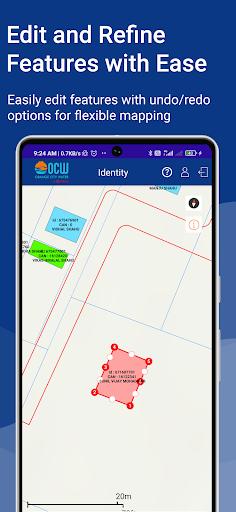
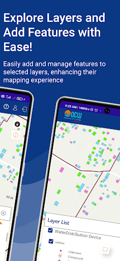
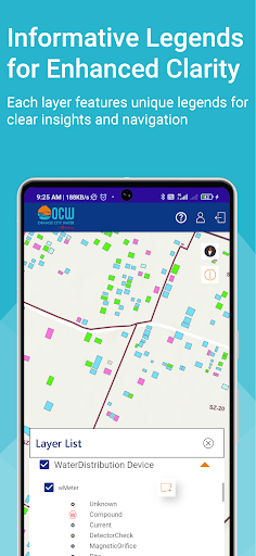
Editing Toolbar - This functionality helps the user to add new features, select features for split & merge using the editor's tool.
Save - Editing toolbar will be used to Save the features with activities.
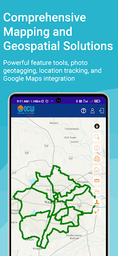
Catching View Area - This functionality helps the user to view all features within a 300 m radius from its position.
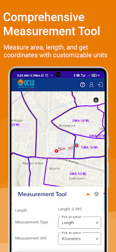
Measure Distance - Measure distance functionality in the mobile GIS application is used to measure distance. Users can measure the length of a line drawn over the map and calculate the segment length of a polygon drawn over the map.
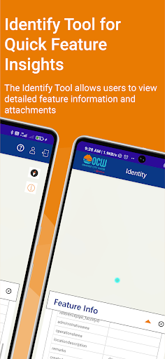
Identity - This function allows the user to view the relevant information of the features when the user clicks over it using this tool.
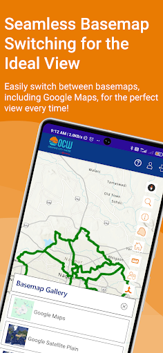
Basemap - This function allows the user to choose from the various maps given in the system.
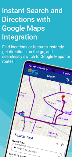
Route - This tool is used to get a route from the source to the destination.
Search Tool - Users will be able to search the features for selected layers. The app will pan to the location and user can select the features on the map to view those features.
Geotagged Photo - This function will geotag the captured image using the user's current location.
Symbology - This function allows the user to view Legend of the map.
North Arrow - This function allows the user to view the north arrow on the map.
Zoom in & Out - This functionality helps the user to zoom in and out on the map.
PAN - This functionality helps the user to navigate or pan on a map.
Refresh Map - This function allows the user to refresh the features within a 300 m buffer area.
App Requirements:
Android OS version 8.0 or above
Compatible with 4G/5G/Wi-Fi networks
For support, users can contact NMC via the toll-free number 1800-266-9899 or email [email protected]. This app prioritizes transparency, ease of use, and robust functionality for an improved water service management.

 Popular IAP
--
 Version History
Ranking Trend
Last 7 Days
Last 30 Days
 Customize
Last 7 Days
Last 30 Days
Customize
Last 7 Days
Last 30 Days
Customize
Last 7 Days
Last 30 Days
Customize
Download Trend
Last 7 Days
Last 30 Days
Last 90 Days
Customize
More by【Veolia It】
| # | App | App Category | App Price | App Initial Release Date | |
| 1 |
|
hubv
Veolia It
|
Business | Free | 26 सित॰ 2022 |
| 2 |
|
OCWGIS
Veolia It
|
Business | Free | 29 दिस॰ 2024 |
| 3 |
|
Nagpur Jal Grahak Sewa
Veolia It
|
Business | Free | 7 जन॰ 2025 |
| 4 |
|
Sampark OCW
Veolia It
|
Business | Free | 11 अक्टू॰ 2022 |
| 5 |
|
vats
Veolia It
|
Business | Free | 18 जून 2025 |