 TikTok
 Instagram
 YouTube

 Home
Home
 Top Influencers
 Explore


Trail Finder: Hike offline
Free Trail / Footpath offline mapping app for Walkers & Rambl...

5+
Total Global Downloads-
Bundle ID
com.storagetools.julesislost
-
Developer
Storage Tools -
Category
Maps & Navigation -
Price
Free -
Update Time
Jul 11, 2025 -
0 Ratings
0
-
Bundle ID
com.storagetools.julesislost -
Developer
Storage Tools -
category
Maps & Navigation
-
Price
Free -
Update Time
Jul 11, 2025 -
0 Ratings
0
 Screenshots & Media


 App Info
 ***********
 Description
An app designed for people who walk Trails and Footpaths.Maps are stored on your device which are optomised for walking. Map coverage is worldwide and all for free.
An easy to use compass which identifies the nearest town or village in every direction. (just like at some trig points)
The rain forecast.
Plots all of the nearby pubs and bars. (click on the orange dots for the name)
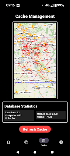
When you install the app it will download maps and location information ('Caching') 6 km radius around your current position. As you walk around with the app running, more map 'tiles' are download to your device when you have an internet connection. The maps are stored on your device for a minimum of 4 weeks. You can cache multiple map areas.
You can 're-cache' stored data using the 'Refresh Cache' button on the Cache tab. - The ability to store local walking route maps when on holiday / vacation in a foreign country is a real bonus - use hotel wifi to download and avoid mobile data roaming charges when out of your home country.
This app is not designed to compete with apps where you have to pay a subscription for offline maps) - It's ideal for casual walkers in the UK or when you are outside of the UK.
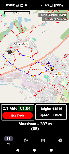
Easy to see footpaths in the vicinity.(red dotted lines)
Footpath finder - The phone will vibrate and the pointer will change colour from blue to red, if you're within 10m of a footpath.
A tracking facility to record your walk, showing the route taken with added 250 m direction of travel markers and black mile markers.(blue line)
Current altitude and walking speed
Touch zoom in/zoom out and centre map
The nearest town or village to your current location (distance and direction)

 Popular IAP
--
 Version History
Ranking Trend
Last 7 Days
Last 30 Days
 Customize
Last 7 Days
Last 30 Days
Customize
Last 7 Days
Last 30 Days
Customize
Last 7 Days
Last 30 Days
Customize
Download Trend
Last 7 Days
Last 30 Days
Last 90 Days
Customize
More by【Storage Tools】
| # | App | App Category | App Price | App Initial Release Date | |
| 1 |
|
Trail Finder: Hike offline
Storage Tools
|
Maps & Navigation | Free | Jun 13, 2025 |